How Isarsoft Perception can be used to measure Space Usage in Train Stations
Isarsoft Perception can be used to measure the usage of available space at train stations. Important not just for infrastructural improvement, this function also helps personnel understand the flow of people in the train station and what can be done to simplify it.
Published
January 8, 2024
.avif)
What is Space Usage in a Train Station?
Space usage is a term that refers to the usage of space by people, objects, infrastructural components, and unaccounted-for entities. In a train station, the usage of space is a blanket category that encompasses the people present within the premises, the area covered by seating, elevators, escalators, tracks, and the space that is allotted for signage and structural necessities.
Brought together, these three broad categories constitute the total usage of space.
In this article, we will look more closely at the 'people' aspect of the proposition - and examine how Isarsoft Perception helps users understand how space is being occupied by people in the train station.
Why is the measurement of Space Usage important?
The efficacy of a particular space (and the components in it) can only be measured by assessing how it is being used. In this case, our test subject is the train station - a busy transport hub that witnesses high footfall rates on a daily basis. It is also a time-sensitive operation, with trains coming in and leaving at precise time intervals. It is, therefore, absolutely necessary that the space in train stations be utilized by commuters in the right way.
There is more.
Architects and planners study the usage of space to make improvement road-maps. Based on how the space is being currently utilized by those it was designed for, they evaluate the impact of a specific entity and decide if it needs any tweaking. Take, for example, a platform that is too narrow. Lack of adequate area will lead to overcrowding during peak hours, and may even lead to unfortunate accidents.
Infrastructural improvements aside, space usage is also a good indicator of occupancy measurement. Especially relevant for train stations, it can help personnel better understand how foot traffic varies through the day, and during periods of high demand. This, in turn, results in better staff deployment and conservation of resources.
How can Isarsoft Perception be used to measure Space Usage?
People Counting
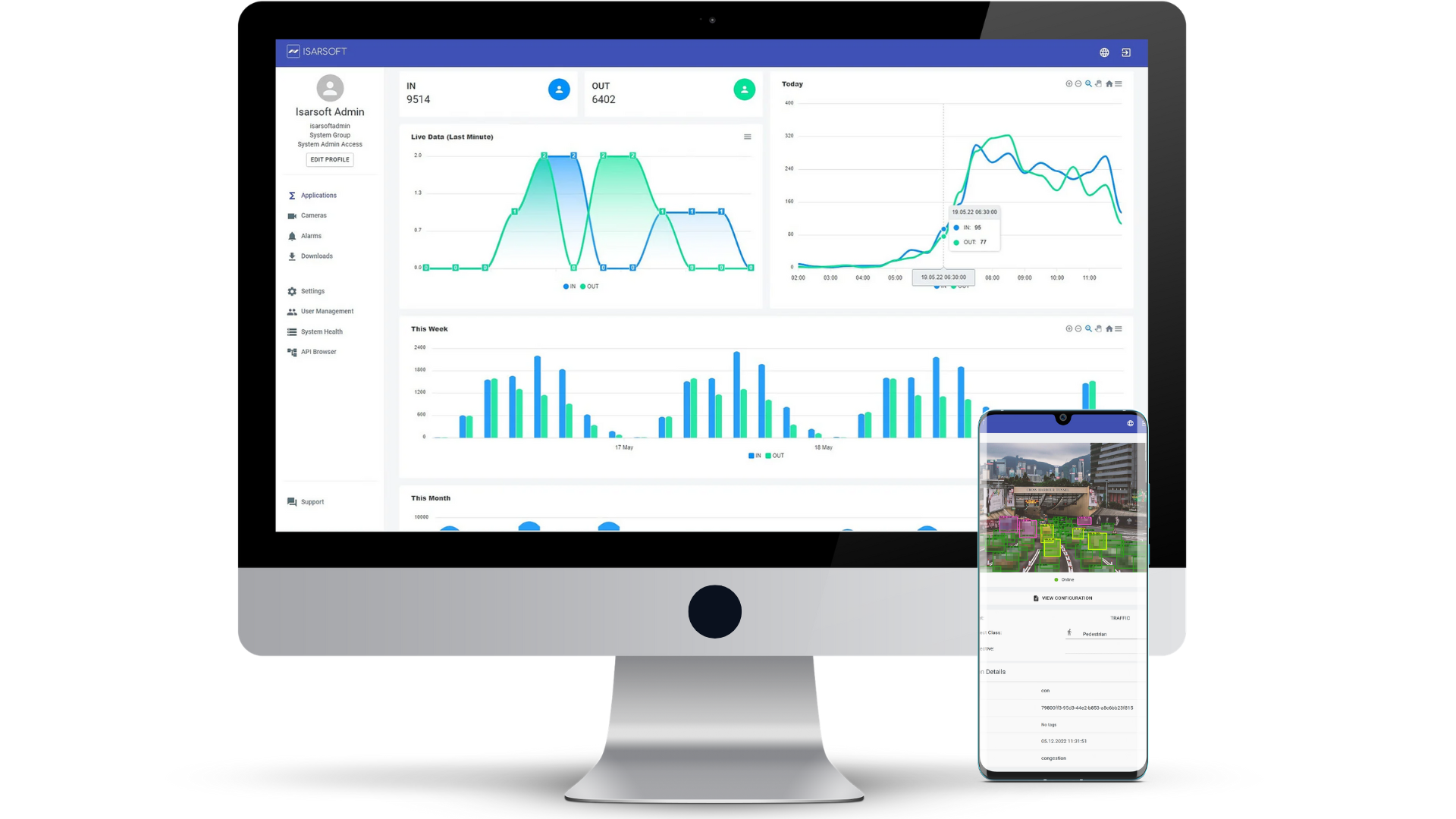
First on the list, an Isarsoft Perception staple and the most obvious choice: people counting. Key to studying any space is to measure the number of people who inhabit it at any given moment. Thanks to Isarsoft Perception's consistent monitoring video data, users can keep track of the number of people in the train station through the day.
Isarsoft Perception also allows users to monitor specific areas. If, for example, an user chooses to focus on the platform, he can create a zone using the Object Flow application. The number of people within the zone will be constantly measured, and the user will be able to observe a sudden entry or exit of detected objects.
.jpg)
Heat Maps
To explain adequately how Isarsoft Perception performs visualizations in train stations, we have compiled a list that explains each map in detail. The list is as follows:
Position Map
Heat maps are traditionally used to visualize and represent a geographical distribution of data, in this case, detected objects on a train station. A position map is a specific kind of heat map that is used to visualize the positions of the objects in a given instant of time, as well as in continuation.
Planners can use this map to assess relative positioning, infrastructure, usage and efficacy of existing structures and standards. The color index is as follows: red signifies high population, yellow indicates scattered populace and blue/turquoise is for low amounts of population.

Path Map
A path map is a way to visualize paths by detected objects at the time of observation. Planners and decision-makers use path maps to assess commonly frequented paths, flow of traffic and pedestrians, favored routes and occupancy figures.
The color index is the same as for the position map above.

Dwell Time Map
Dwell time heat maps are self-explanatory, they are tools of visualization that are used to assess the dwell time of detected objects pictorially. They can be implemented in the context of train stations to analyze wait time figures, and evaluate the efficacy of train schedules. Areas marked in red indicate areas where detected objects dwelled the longest. Yellow and blue, respectively, are for shorter spans of time.
They can also be used to conduct infrastructure usage monitoring, and accessible placement of ATMs, ticketing machines and shops in the premises of the station.

Velocity Map
Velocity maps are especially useful in the context of train stations as they can be used to track the location and speeds of detected objects. The image below is a velocity map of the train station under observation in this article.

Trajectory Mapping
A trajectory map, as can be seen in the image below, is a cartographic representation of individual trajectories. A map of this kind serves the purpose of tracing routes, and thereby, gathering information on infrastructure usage figures, possible design changes, and efficacy.
It can also be used to streamline the passenger flow within, into, and out of the station.

Video Tutorial
The video above depicts a typical passenger counting case study- in a train station. Through the counting of passengers, users can access actionable insights about occupancy and the usage of space.
What are the benefits of using Isarsoft Perception?
Better Understanding of Data
Visualization is instrumental in aiding planners to understand huge volumes of data, easily and quickly. Any visualization process involves working with a large amount of data, and very conveniently packing it into graphical or pictorial form to instant comprehension without actually having to study the data.
Isarsoft Perception’s visualization maps do the same, with each map focusing on a particular KPI and highlighting it to promote ease of use.
Quick Response Time
One of the primary reasons inducing the fast growth of video analytics use is the fact that it allows personnel to respond quickly. Whether it is a situation involving safety-critical factors or an event where staff deployment needs to be optimized, visualizations help security and planning staff be better equipped to handle any kind of situation, anticipated or not.
Provides Access to Insights
Isarsoft Perception’s suite of visualization maps are calibrated carefully, with each map positioned to focus on a specific KPI. The visualizations are part of the Object Flow application and prove especially useful in the context of visual comprehension.
They provide access to certain insights as a result of the medium of display that perhaps would be difficult to spot in traditional reports.
More about Isarsoft
With Isarsoft Perception, your camera systems become part of your business intelligence. Whether the goal is to increase efficiency, customer satisfaction or safety, Isarsoft Perception provides the insights needed for informed decisions.
Contact us, to learn more about how to turn security cameras into intelligent sensors.
Explore More Publications
.avif)
Optimizing the EES bottleneck: Why Airports choose Video Analytics for Queue Management
With the real-world EES processing times taking up to 5 minutes per passenger, legacy airport queue models have officially collapsed. Discover how airports are using AI-powered video analytics to transform their existing cameras into predictive tools that eliminate terminal bottlenecks before they form.
.avif)
Video Analytics or Sensors? Finding the best People Counting Tech for your Business
Do you want to improve your business by adopting a people counting solution but feel overwhelmed by the options? With video analytics and sensor-based technologies offering different advantages, choosing the right system can be challenging.
.avif)
Who are your customers? Detection of age, gender, and group size in retail
Retail stores are often a blackbox when it comes to customer demographics. When POS checkout systems and customer loyalty programs do only reveal a part of the story, video analytics can now cluster store visitors in age groups and match them to male and female gender.