Using Heat Maps to analyze Traffic Flow: The Isarsoft Approach
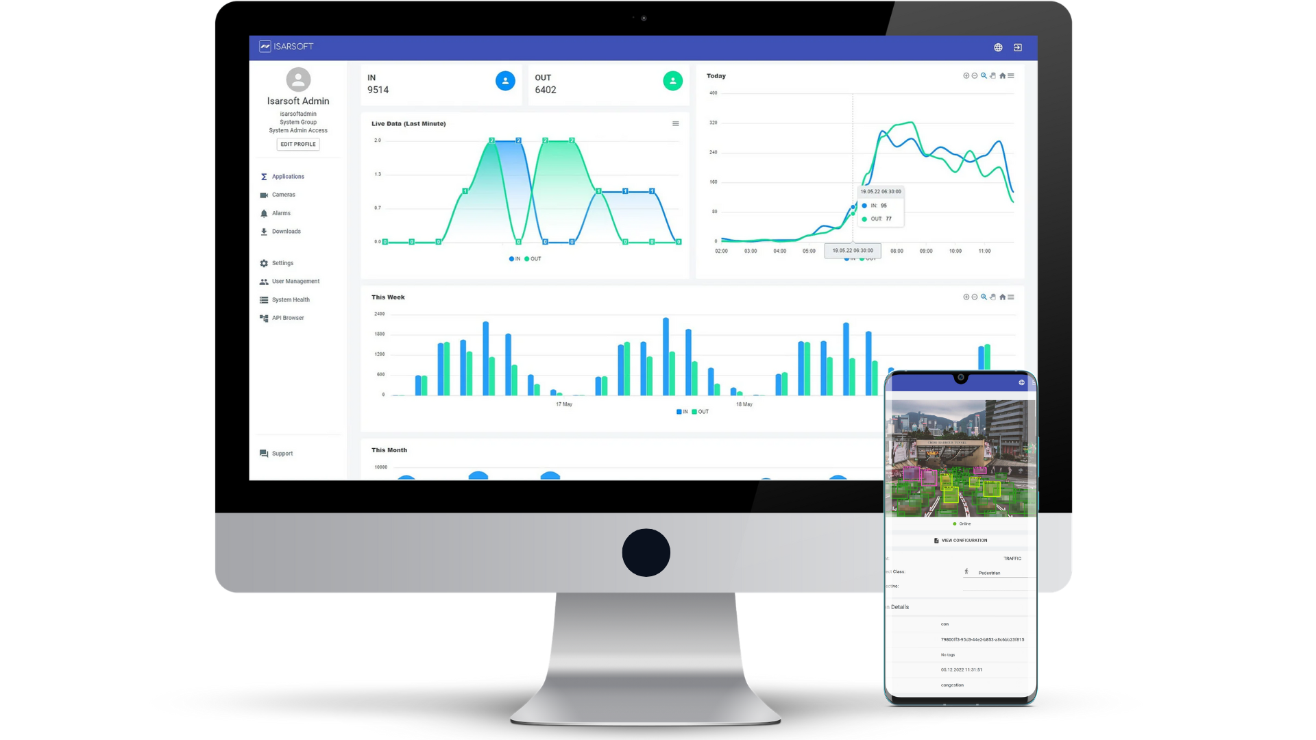
Isarsoft Perception offers users access to a range of heat maps, which can be used to analyze and assess the flow of traffic. Here's how.
Published
February 10, 2023
.avif)
A heat map, briefly summarized, is a representation of a large amount of data in the form of an image or map wherein the data is shown as colors. The variation is indicated by a shift in hue or intensity, thereby providing obvious visual cues as to how the data is clustered or spread out over space.
Isarsoft Perception offers users access to a set of six different visualizations. This set includes four different heat maps (path map, position map, velocity map, dwell time map), a trajectory map, and the preliminary detection image.
In this article, we will analyze the six different visualizations and their contribution towards assessing traffic flow.
Why are heat maps useful in traffic analysis?
The analysis of traffic flow is a fast-paced, quickly changing process that simultaneously involves the processing of large amounts of data. What makes the subsequent assessment easier for traffic personnel and highway patrol is having easy-to-read visual cues instead of actual data. This is where the heat maps come into play.
Heat maps provide a holistic view of the internal processes without a major loss in clarity, which is ideal for a quick response time. This is especially important as traffic flow is a safety-critical domain, and often subject to situations needing immediate assistance.
With the help of Isarsoft Perception’s suite of visualizations, it is possible to evaluate traffic flow visually with each map corresponding to a different KPI. While path and position maps are in accordance with location tracking, the velocity map helps the user track the speeds of the detected objects. A dwell time map is used to gain an overview of individual and collective dwell times, while the trajectory map provides insight into commonly frequented routes.
We shall delve deeper into each category in the next section.
The Isarsoft Approach
Location Detection and Monitoring
Isarsoft Perception provides two different maps that are configured to aid users in location detection and tracking - path map and position map.
A position map indicates, on a map, where objects are located. The process is conducted with the help of a thermal imaging camera. The color coding of the data works as follows: crowded areas are marked in red, yellow means that the area is not as highly frequented, and blue/turquoise is used to indicate empty or very rarely frequented spaces.
In the context of traffic, the position map can be used to assess traffic flow at any given time. By having an idea of which parts of the road are receiving high volumes of traffic and which are not, personnel can be deployed accordingly to commandeer the traffic and eliminate any hold-ups.
Data observed over a period of time can be used to create a database. Frequently high-performing areas, in terms of traffic, can be identified and have provisions such as more signage, added infrastructure, traffic signal optimizations made for them.

A path map functions on the same color scheme as a position map, and is similarly generated with the help of a thermal imaging camera. The path map can be used to indicate and figure out which paths are being taken most frequently - an easy analysis, since the best performers would be marked in red.
This information is relevant in city planning and development as it can help architects and designers distinguish popular routes from the ones that are not as popular. It gives insight into the commuting preferences of citizens, and can be used to improve road conditions.

Speed Tracking
The speed of vehicles, i.e, detected objects can be tracked by a velocity map. A thermal imaging camera analyzes the datasets corresponding to respective velocities and then displays them in an unified image that is easy to understand.
The color coding scheme remains the same; red is for fast-moving traffic while yellow and blue indicate slower speeds. This information is used by planners and decision-makers to devise and revise safety protocol and speed limits, depending on the situation.

For example, the image above is a velocity map wherein the vehicles seem to slow down as they approach the intersection, alluding to the existence of traffic signals at specified locations.
Dwell Time Measurement
A dwell time map refers to an image that displays the areas in which detected objects linger. Red signifies long dwell times, while yellow and red are indicative of shorter time spans.
In traffic analysis, dwell time is used to detect hold-ups, accidents, bad road conditions that might slow down traffic, and congestion. All of these are important variables to take into consideration when streamlining traffic flow and optimizing road conditions to facilitate easier travel.

Benefits of using Heat Maps
Easy Comprehension
The primary advantage of heat maps is that they process vast amounts of data to generate visual results that can be comprehended in a matter of seconds. Heat maps can be understood intuitively, thanks to a simple color scheme.
Facilitates Quick Response Times
The analysis of traffic is a process that requires near-constant supervision, owing to the presence of several variables that exist simultaneously and the high probability of occurrence of safety-critical incidents. It is, therefore, very useful to have a tool such as heat maps that synthesize data into an easily readable form and facilitate quick response times.
KPI Measurement
The term ‘KPI’ stands for Key Performance Indicator, alluding to variable-based assessment of performance. Isarsoft Perception’s set of visualizations are all configured to assess relevant KPIs, for example, speed, dwell time, location, etc.
Access to heat maps that focus on individual KPIs makes the process of analyzing traffic flow infinitely easier.
More about Isarsoft
With Isarsoft Perception, your camera systems become part of your business intelligence. Whether the goal is to increase efficiency, customer satisfaction or safety, Isarsoft Perception provides the insights needed for informed decisions.
Contact us, to learn more about how to turn security cameras into intelligent sensors.
Explore More Publications
.avif)
Video Analytics or Sensors? Finding the best People Counting Tech for your Business
Do you want to improve your business by adopting a people counting solution but feel overwhelmed by the options? With video analytics and sensor-based technologies offering different advantages, choosing the right system can be challenging.
.png)
Who are your customers? Detection of age, gender, and group size in retail
Retail stores are often a blackbox when it comes to customer demographics. When POS checkout systems and customer loyalty programs do only reveal a part of the story, video analytics can now cluster store visitors in age groups and match them to male and female gender.
.avif)
How to: Customer Journey Analysis with Re-ID in Retail
Customer journey analysis with Re-ID provides the retail industry with precise data on footfall, customer behavior, and space utilization. Based on these insights, retailers can make smart decisions for both marketing and operations.